
Features Timmerweb
Timmerweb App is for you who are a user of the web service Timmerweb.
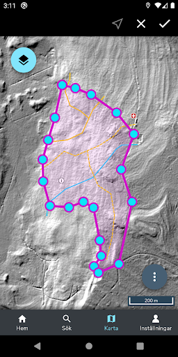
The app, which is a new version of the old predecessor from 2013, is a support for you who want to work with action objects in the field.One of the main upgrades in the new Timmerweb App is map management.
As long as you have a connection, you can stream map data - but if necessary, you quickly cache large map areas directly on your device for complete offline support.
The following map layers are included in the first version of the app:Orthophoto* Metria Background Map* Shaded ground model* Soil moisture map* Nature reserve* Key biotopes* Natural values* Nature conservation agreement* Water protection areas* Forest close to the mountains* Elevation curves* Property boundaries* Forest and History* Ancient remainsOtherwise, you will find basically the same functions as in the old Timmerweb app, which in short is:Create, search, retrieve and edit action objects* View position and track with GPS* Draw and edit geometries* Save and sync* Show property on the mapYou use the same login as for Timmerwebs GIS client, provided that you or your company have access to the apps server services.
Keep in mind that GPS running in the background can affect battery life.
Social Features
Connect and share with friends and the community.
Camera Features
Advanced camera features with editing capabilities.
Fitness Tracking
Track your workouts and monitor your health metrics.
See the Timmerweb in Action

Get the App Today
Available for Android 8.0 and above